In short
Google removed a newly launched Google Earth AI image feature one day after release after critics warned it could be used to spread misinformation. The company says it will return only after adding stronger safeguards.
- Google rolled back a Google Earth AI image feature just one day after launch.
- Critics said the prompt-based tool could make misleading map-based imagery easy to create.
- Google said some generated screenshots appeared to violate its policies.
- The company plans to add stronger guardrails before considering a future release.
Google has withdrawn a newly launched Google Earth AI image feature just one day after debuting it, after critics warned it could be used to generate misleading satellite-style pictures and spread misinformation. The company said it would pause the tool while it adds stronger safeguards.
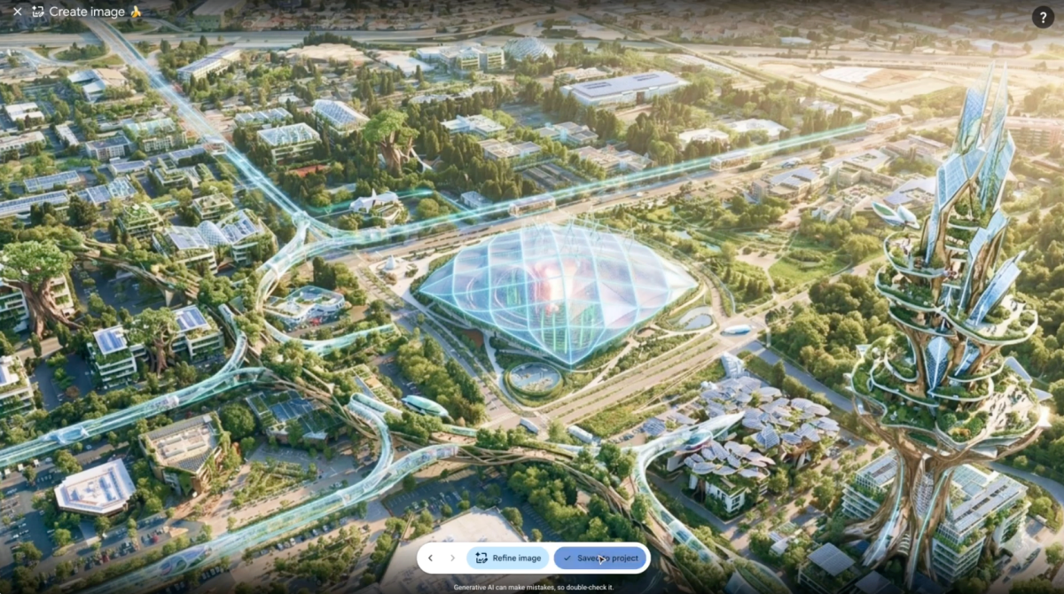
The short-lived feature let users apply Nano Banana 2, Google’s AI image generator, to create fabricated visuals layered over Google Earth imagery. Google framed the release as a creative way to experiment with geography, but the prompt-driven system immediately raised alarms because it could place almost any generated image on top of real-world maps.
Within hours, researchers, journalists and other observers said the feature risked turning one of the world’s most trusted mapping products into a source of “geospatial slop” — synthetic images that look grounded in location data but may have little or no connection to reality. Google has now reversed course.
What Google launched, and why it mattered
Google Earth is widely used by journalists, researchers, educators, emergency planners and ordinary users because it provides a familiar, visually grounded view of the planet. Any tool that can alter that visual record — even for creative purposes — immediately raises questions about trust.
The new feature introduced on Thursday allowed users to generate fabricated imagery inside Google Earth using Nano Banana 2. In practical terms, that meant a user could prompt the system and place AI-created content over satellite and map views, giving the appearance of being tied to a real location.
That distinction matters because geospatial imagery is often treated as evidentiary material. A screenshot from a mapping product can support a news report, a research project, an investigative claim or a public discussion about land use, infrastructure or environmental damage. Once synthetic imagery is mixed into that environment, users need to know exactly what is real and what is generated.
Why critics reacted so quickly
Criticism centered on the speed at which believable falsehoods could be produced. Unlike traditional editing tools, modern AI image generators require little skill and can create polished, persuasive visuals from a simple text prompt.
That ease of use has changed the misinformation landscape. A convincing fabricated image no longer requires advanced design expertise; it can be produced in seconds, then reposted in a way that suggests it came from a reliable geographic source.
A BBC journalist mocked the feature on social media, saying sarcastically that there was “no way” an AI image generation tool inside Google Earth could be abused to spread misinformation.
The point of the comment was clear: critics saw the risk immediately. A mapping platform is not just another creative canvas. It is a product built around location, context and credibility, which makes synthetic additions more consequential than ordinary internet image manipulation.
Why did Google kill the feature so fast?
Google removed the feature because it said some users were already producing screenshots that appeared to break its policies. The company also said geospatial professionals had found practical uses for the tool, but that those benefits were outweighed by the policy and trust concerns surfacing almost immediately.
In a statement, Google said it had seen people using the feature for legitimate work, but also saw examples of generated imagery that seemed to violate its rules. The company added that it was rolling the feature back in Google Earth while it works on better guardrails.
That rapid reversal suggests Google concluded the public launch arrived before the company had enough controls in place to manage abuse at scale. For a product as visible as Google Earth, even a short window of misuse can be enough to trigger reputational damage.
How the rollback reflects a larger AI pattern
The episode fits a familiar pattern across the consumer AI market: companies release a powerful new capability, then race to patch safety gaps once public pressure reveals the risks.
This is especially common with generative image tools. They can be entertaining and useful for design, education and prototyping, but they also make it trivial to manufacture content that seems documentary, location-specific or authentic.
Google’s retreat also underscores a broader tension inside major AI companies. They are being pushed to add generative features everywhere, yet every new surface area creates another potential misuse case. In mapping, that risk is amplified because the product already carries an implied promise of accuracy.
| Event | What happened | Why it matters |
|---|---|---|
| Thursday launch | Google added an AI image generation feature to Google Earth using Nano Banana 2. | It allowed fabricated images to be layered into a trusted mapping product. |
| Immediate criticism | Journalists and others warned it could be used to spread misinformation. | Concerns focused on misleading geospatial imagery and easy abuse. |
| One day later | Google rolled back the feature. | The company acknowledged policy violations and promised stronger guardrails. |
How could an AI feature inside Google Earth be misused?
It could be misused by making generated images appear tied to a real place, which gives false material a veneer of geographic credibility. That is the central problem critics identified.
Because the feature was prompt-based and broadly permissive, users could ask the model to create visuals that were then superimposed over map imagery. In a social media environment where screenshots travel faster than context, that kind of output can be detached from the original tool and recirculated as apparent evidence.
The danger is not limited to blatant hoaxes. It also includes subtle distortions: altered environmental scenes, fake infrastructure, misleading disaster imagery or fabricated views of remote areas where verification is difficult.
Examples of possible abuse scenarios
- Fake flood or wildfire damage layered onto a map location
- Manufactured construction or military imagery appearing to show a real site
- Altered land-use or environmental screenshots used to support a false claim
- Social posts that strip away context and present generated visuals as documentary proof
None of those scenarios require sophisticated technical skill. That is part of the problem. The easier the generation process becomes, the broader the misuse surface.
What Google said in response
Google’s statement emphasized both the feature’s legitimate utility and the policy issues it had already encountered. The company said it observed “geospatial professionals” using the feature for useful work, but also saw generated screenshots that appeared to break its rules.
Google said it was removing the capability from Google Earth for now and would reintroduce it only after adding stronger safeguards.
That language signals a temporary retreat rather than a permanent abandonment. The company is not necessarily rejecting the idea of AI-assisted cartographic creativity; instead, it appears to be admitting that the first version was too open-ended for a product with Google Earth’s credibility.
What stronger guardrails might involve
Google did not spell out the exact controls it plans to add, but any future version would likely need more than basic content moderation. In this context, stronger guardrails could include clearer labeling, stricter prompt limits, visible provenance markers and restrictions on how generated imagery can be displayed or shared.
It may also require product design changes that distinguish synthetic output from source imagery more aggressively. Without that separation, users may struggle to tell whether a visual element reflects the map or the model.
Why this matters beyond one product
The rollback is significant because it highlights a fault line running through the entire AI industry: companies want to make generative tools feel useful and integrated, but every integration also increases the chance that synthetic content will be mistaken for reality.
That problem is particularly acute in areas where evidence and trust are central. Search engines, news feeds, social platforms and mapping products all sit near the top of the information chain. When AI features are inserted into those systems, the burden on users to distinguish fact from fabrication rises sharply.
In recent years, the internet has already been flooded with low-quality AI images, sometimes called “slop,” that fill feeds with convincing but empty visuals. Google’s brief Earth experiment suggested a new frontier: not just generic synthetic pictures, but fake imagery tied to a place on the planet.
That is a more dangerous category because location adds credibility. A picture that looks like it came from a specific map view can feel more legitimate than a random generated image, even if both are equally synthetic.
How the AI misinformation debate keeps evolving
The backlash to Google Earth’s feature lands in a year when AI companies are under growing pressure to explain how they will limit deception without stifling experimentation. There is broad public enthusiasm for generative tools, but there is also a rising awareness that low-friction content creation can overwhelm verification systems.
For years, digital misinformation relied on editing expertise, stolen photos or clumsy fabrications. AI has compressed that pipeline. A user can now prompt a system to create a compelling image in seconds, then share it widely before anyone has a chance to check the source.
That makes product design decisions much more important than before. A feature that might seem harmless in a lab or demo can become problematic when it is embedded in a trusted consumer product with global reach.
Why trusted platforms face a higher bar
Google Earth is not a niche art tool. It is a reference product used to inspect places, compare terrain and understand real-world locations. That means the company’s standards for synthetic content have to be stricter than those of a standalone image app.
Users often bring an assumption of accuracy to Google’s mapping ecosystem. Even a small amount of ambiguity can erode confidence, especially if screenshots circulate without context.
Once trust declines, recovery can be difficult. Rolling the feature back quickly may help Google contain the immediate backlash, but the company will still have to show that any future release is visibly safer and easier to interpret.
What happens next?
Google says it will work on stronger protections before deciding whether to restore the feature. For now, the company has effectively admitted that the launch version did not meet its own standards for a product so closely associated with real-world imagery.
The episode may also influence how other companies think about blending generative AI with mapping, search and other high-trust products. The lesson is straightforward: the more a product depends on credibility, the more carefully synthetic content has to be bounded, labeled and constrained.
In the short term, the rollback may ease concerns among researchers and journalists who rely on Google Earth as a visual aid. In the longer term, it could become a case study in how not to introduce generative AI into a trusted platform.
For now, Google has done what critics wanted: it pulled the feature back almost immediately. The deeper question is whether the next version can preserve creativity without turning a mapping tool into a factory for believable falsehoods.
Key facts at a glance
| Detail | Information |
|---|---|
| Company | |
| Product | Google Earth |
| Feature | AI image generation using Nano Banana 2 |
| Launch date | Thursday, July 31, 2026 |
| Rollback timing | One day after launch |
| Reason cited by Google | Generated imagery appeared to violate company policies |
| Next step | Google says it will implement stronger guardrails |
Bottom line
Google’s rapid retreat shows how quickly AI features can collide with trust and misinformation concerns when they are added to products people rely on for real-world accuracy. The company launched a creative tool for Google Earth, but the risk of misleading geospatial imagery was obvious enough that it pulled the plug within a day.
Frequently asked questions
What did Google remove from Google Earth?
Google removed a new AI image generation feature that let users use Nano Banana 2 to create fabricated visuals inside Google Earth. The company said it was rolling the feature back while it works on stronger safeguards after policy concerns surfaced.
Why was the Google Earth AI feature criticized?
The Google Earth AI feature was criticized because it could let users place convincing synthetic images over real map imagery, making it easier to spread misinformation. Critics argued that a trusted geospatial product should not make fabricated visuals look location-based.
How long was the feature available?
The feature was available for only about one day. Google launched it on Thursday and announced the rollback shortly after, saying it had already seen generated screenshots that appeared to violate company policies.
Will Google bring the feature back?
Google has not ruled out bringing it back, but it says any return will depend on stronger guardrails. The company described the rollback as temporary while it works on ways to reduce misuse and improve policy enforcement.
Why does this matter for misinformation?
This matters because mapping products are often treated as evidence of what is really happening in a place. If AI-generated images can be blended into that environment, false content may gain extra credibility and spread more easily online.